Ask people to define “geography,” and most of them will initially say it is location — where a place is. The “where” is certainly central to geography, and with tools such as maps and global positioning technology, geography is the subject best equipped to address a question about location. However, a simple exercise will illustrate that geography is much more than just location.
Imagine that the state of Mississippi was able to exchange places with the state of Alaska. Not only would its location be much farther north, but what else about the state would change as a result of the shift in latitude? How would Mississippi’s history, her people, and their cultures, have been different if the state had been situated along the Arctic Ocean and Bering Sea instead of along the Gulf of Mexico and the Mississippi River?
Geographers use “so what?” questions to invite investigation of such queries. These “so what?” questions give geography meaning and expand study of the subject beyond basic location and a collection of place names, coordinates, and capitals. It is when geography explores the “so what?” questions, as well as the “where?” question, that the subject comes alive and shows the excitement and wonder, as well as the difficulties and challenges, that our incredible planet can offer.
What other questions might geography answer about a place? The National Geographic Society and other professional geographers suggest focusing on the five themes of geography, or five areas that help describe a place — location, place, human-environment interaction, movement, and region. Let’s explore those five themes as they relate to Mississippi.
Location
Geography’s fundamental question about a place — where is it? — is answered in the theme of location. The answer to the “where” question can relay a wealth of information without which little else can be understood. Mississippi’s location can best be explained in both absolute and relative terms. The state is located between 30 degrees and 34 degrees north latitude, or the lower middle latitudes. This places the state in the temperate climate zone in the northern hemisphere. Mississippi is also located in the western hemisphere with a longitude ranging from 88 to 91 degrees west. The combination of latitude and longitude coordinates gives the state its absolute location.
Describing the state in terms of where it is in relation to other places is relative location. Mississippi is bordered on the east by Alabama, by Tennessee on the north, by Louisiana and the Gulf of Mexico to the south, and by the Mississippi River on the west. These boundaries outline an area approximately 48,000 square miles with a north-south length of 350 miles and an east-west width of 180 miles. It ranks number 32 in size among the states of the United States and lies in the geographic center of the Gulf South.
Once the “where?” questions are answered and we know the state’s location, we can enhance the study of its geography by asking other questions: So what if Mississippi is located in the lower middle latitudes? What does it mean that the state is bordered by the Mississippi River? How has the state been shaped by where it is located?
Place
Answers to some of these questions can be found by studying the theme of place, which answers a second essential question: what is it like there? what does the place look like, feel like, sound like?
Mississippi has distinctive tangible and intangible characteristics that distinguish it from all other places. Describing the state can be organized into its physical (natural) and human (cultural) aspects. Physical characteristics of the state include a humid subtropical climate with an average annual temperature of 62 degrees Fahrenheit (the ninth warmest state in the union) and an average annual precipitation of around 52 inches. Another telling physical statistic is that Mississippi averages more than 220 frost-free days a year. The state often experiences natural hazards such as thunderstorms, tornadoes, floods, and hurricanes.
With an elevation of less than 1,000 feet, with much of it below 500 feet, Mississippi is a part of the Gulf Coastal Plains of the United States. Deposits of petroleum, natural gas, gravel, sand, lignite, limestone, and clay can be found in the state’s loamy soils, some of which are alluvial (waterborne) or loess (wind-borne). A number of salt domes have been discovered in the state, extending southeastward from Warren County to George County. Natural water resources include the Mississippi River and nine other major river systems. The flora and fauna of any area also are elements of this theme of place. Flora (natural vegetation) consists of forests (oak, hickory, cypress, and pine), grasslands, and salt grass marshes. The animal life, or fauna, includes deer, squirrels, rabbits, foxes, game birds, freshwater fish, and saltwater yields such as shrimp, crabs, and oysters.
No study of place is complete without taking into account its human or cultural characteristics. Mississippi is home to a population of more than 2.8 million people, including American Indians, French, Chinese, Hispanics, Italians, Slovenians, Lebanese, Vietnamese, and Greeks, most of whom speak English. The largest ethnic groups are white Anglo Americans (61.4 percent) and African Americans (36.3 percent), according to the 2000 U.S. Census. The state’s population is equally distributed between rural and urban areas; the population density is 62 persons per square mile, which is low compared to such states as New Jersey (1,138 persons per square mile), or even neighboring Louisiana (102 persons per square mile). The majority of church members in Mississippi are Protestant, with Baptist congregations making up the largest group. Other denominations include Methodists, Presbyterians, Episcopalians, Lutherans, and Catholics. There are smaller numbers of Hindus, Jews, and Muslims.
Another important aspect of “place geography” is human livelihoods. Mississippians engage in primary economic activities such as agriculture, fishing, timber, and mining. These activities involve the extraction of natural resources. Secondary human livelihoods consist of the production and manufacture of finished goods. About 29 percent of the state’s workforce is engaged in the secondary sector, producing an assortment of goods, from automobiles, household appliances, furniture, food, lumber, wood products, to textiles. Ingalls Shipbuilding, located in Pascagoula, is the largest private employer in Mississippi. Its workers produce, design, and overhaul military and commercial marine vessels. Tertiary human livelihoods, or third in rank, provide a wide array of services in return for monetary compensation in which more than 65 percent of Mississippians work. They include retail sales, education, insurance, banking, law, real estate, recreation and tourism, and health care and medicine.
Place characteristics also include information on politics and government, education, and standard of living. Taken together, the physical and human elements of place provide a rich palette from which a more accurate picture of the state can be drawn. A natural extension of the study of place is to ask the “so what” questions. What impact does an increasingly diverse population have on the state? What is the significance of a closely aligned rural to urban ratio? In what ways has the state’s rich outpouring of music, literature, and art been influenced by the place? When considering the scope of recent natural disasters, how should the government respond to rebuilding efforts in risky locations? What conditions of place are both beneficial and problematic, a dilemma referred to by geographers as “geographical irony?”
Human-environment interaction
What to do about the Mississippi River is a clear example of geographical irony, and sets the stage for reviewing the theme of human-environment interaction. For eons, the mighty river has tracked its way to the ocean, flooding millions of acres with rich silt, thus constituting some of the most fertile land in the world. An easy answer to the “so what” question here, what to do with this productive soil, is to cultivate it. As people began to clear the land, farm it, and live on it, the persistent floods became a nuisance and an economic hazard. A program of levee-building, and eventually the construction of man-made dams and reservoirs, emerged as a way to control the river.
Are there disadvantages to controlling the mighty river? Mississippians continually depend on, adapt to, or modify their natural settings in ways that reveal who they are, politically, economically, technologically, and culturally. A good study of Mississippi’s geography focuses on the how and why of human-environment interactions in the state, as well as the consequences, for both humans and the environment.
Human actions produce both intended and unintended results. Consider the introduction of kudzu into Mississippi to prevent soil erosion, some of which occurred as a result of the clear-cutting policies of timber companies, yet another example of Mississippians modifying the environment. Kudzu proved effective, but its rapid and uncontrolled growth caused other serious problems in the landscape. For example, rangers at the Vicksburg National Military Park struggle continually to maintain the natural, authentic environment against the aggressive kudzu. Numerous examples of this theme can be found everywhere in the state where there is human settlement.
Movement
Humans are widely scattered across Mississippi, as are many of its valuable resources. How these two connect is explained in the theme of movement through which geography helps explain how and why people, goods, and ideas move. Major waterways such as the Mississippi River and the Gulf of Mexico provided transportation for early settlers. How much more isolated the area would have been in its formative years without these natural features.
Today, complex systems of communication and transportation connect Mississippians with each other and, increasingly, with the entire world. Gulfport, Mississippi, remains one of the largest banana receiving ports in the world. Both agricultural and manufactured products of the state are shipped globally, even as Mississippians take advantage of goods imported into the state. Blues music and the literature of William Faulkner have spread and have aficionados worldwide.
Geography explores the economic and psychological reasons for the great migration into the Mississippi Territory at the turn of the 19th century, and for the great migrations from the state during the early and mid-20th century, and maps the routes of those leaving. With respect to the great migration, what patterns can be identified and explored that explain this phenomenon? What ramifications did the mid-20th century exodus have on Mississippi and on areas where these thousands relocated? Another example is the hundreds of German prisoners of war who were brought to Mississippi during World War II. Why and “so what?” Finally, what highways, railroads, and airports currently serve as avenues of movement across the state and nation? Charting and analyzing the movement of goods, ideas, and people is essential in understanding how Mississippians are linked to each other and to the world.
Region
Just as the place theme details the uniqueness of the state, the theme of region indicates how Mississippi is a part of an area that displays commonalities in selected criteria. A region can be determined by physical characteristics (soil, climate, topography, etc.) or by cultural criteria (language, religion, politics, etc.). The scale of the region can be as large as the southeastern area of the United States, or as small as the divisions of a city: residential, industrial, educational, etc. Some regions are functional, such as a school district or an athletic conference, or perceptual. Mississippi, for example, is considered by some as part of the “Bible Belt.”
Mississippi’s physical attributes place it squarely in a plains region, a temperate region, an agricultural region. Within the state, numerous smaller-scale regions can be identified: tourist region, catfish production region, timber region, and certain landform regions. Regions can change. At one point in its history, the state was part of an entrenched political region affiliated with the Democratic Party. In the late 20th century that changed as a majority of Mississippians cast ballots for the national Republican Party. So what? Geography seeks out these connections and explores the economic, cultural, physical, and perceptual reasons behind their formation. On a small scale, regions enable the state to more efficiently manage and develop areas; on a larger scale, Mississippians are reminded of their place in an increasingly connected world.
William Faulkner once said of his Mississippi home: “I discovered that my own little postage stamp of native soil was worth writing about and that I would never live long enough to exhaust it.” That’s a good definition of geography: writing about or describing a place using the five themes of location, place, human-environment interaction, movement, and region – and asking thoughtful questions.
Martha Hutson is professor of history and geography at Mississippi College, is a teacher consultant with the Mississippi Geographic Alliance, and is a developer of lesson plans for Mississippi History Now.
Lesson Plan
-
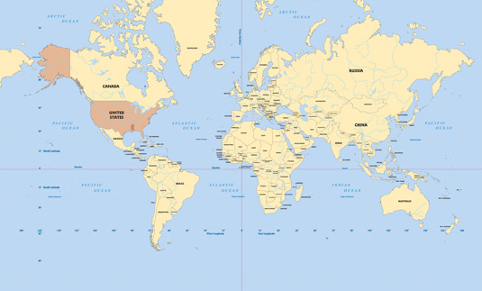
*Location:* Map shows Mississippi's location in the world. Map by Lee Windham, courtesy Clairmont Press, Atlanta, Georgia. -
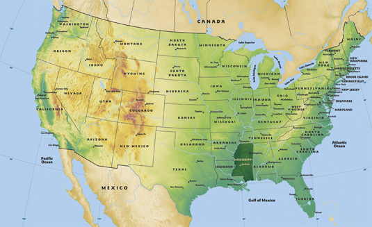
*Location:* Mississippi's location in the United States. Map by Lee Windham, courtesy Clairmont Press, Atlanta, Georgia.
-
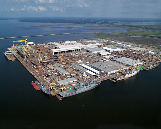
*Place:* The Pascagoula facility of Northrop Grumman Shipbuilding – Gulf Coast is Mississippi's largest private employer. An important aspect of "place geography" is human livelihoods. Photograph courtesy Northrop Grumman Shipbuilding – Gulf Coast. -
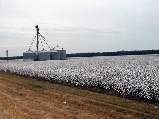
*Place:* A Mississippi cotton field. Mississippians engage in primary economic activities such as agriculture, fishing, timber, and mining. Photograph by Princella Wilkerson Nowell. -

*Human-environment interaction:* Kudzu proved effective in preventing soil erosion, but its rapid and uncontrolled growth caused other problems. Photograph by John Byrd, professor of weed science, Mississippi State University. -
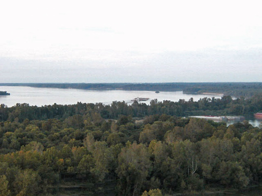
*Movement:* A barge navigates a bend in the Mississippi River near Greenville, Mississippi. Major waterways provide for the movement of goods. Photograph by Princella Wilkerson Nowell. -
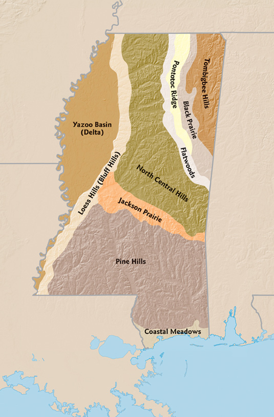
*Region:* The landform regions of Mississippi. Map by Lee Windham, courtesy Clairmont Press, Atlanta, Georgia.
Selected bibliography
Busbee, Westley F. Mississippi: A History. Wheeling, Illinois: Harlan Davidson, Inc., 2005.
Kelley, Arthell. “The Geography.” In A History of Mississippi, Vol. I, edited by Richard Aubrey McLemore. Hattiesburg: University and College Press of Mississippi, 1973.
Websites:
(accessed August 2008)
